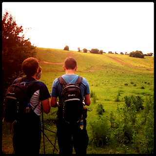
 This weekend we planned our last full team walk, dropping the mileage by almost half of last week's 31 miles. We also fancied a change of scenery after the recent weeks on the Trailwalker route, so we settled on the medieval route of the Pilgrims Trail, a route that takes walkers from Winchester to Portsmouth, and if you are really keen, on to it's final destination of Mont St Michel in Normandy.
It was a sunny, but chilly start in the car park at the foot of St. Catherine's Hill, just south of Winchester, at 7:30. We set off on our planned 16 miles walking through a valley named the Plague Pits to a crossing that took us over the M3, and then on to Twyford Down. We became quickly aware that the paths were to be wet and muddy. This was not a good day to ditch the gaiters, but ditched them we did.
This early part of the walk covered some of the same route that Jo & Julie did on their walk back in early March, where they experienced a range of all weathers. Today though we were thankful it was just sun with the occasional cloud cover.
We skirted around Hockley Golf course on to our first checkpoint destination today, Owslebury, a village that sits not only on the Pilgrim's Trail, but also the Monarch's Way (a 615 mile footpath that approximates the escape route to Shoreham taken by King Charles II in 1651 after being defeated in the Battle of Worcester), and also a Roman Road that works its' way to Portchester, which we were also to walk along for some distance today. It can also boast at being the highest village in Hampshire.
Here we met support crew Gem & Anna on the lawn in front of the medieval church for some snacks and stretches. On the menu today was Gem's pecan chocolate brownies and peanut butter fudge, very tasty.
 |
| Erm...which way? |
He was sitting down so we felt comfort that we'd have a little notice if it had decided to take offence of our presence. Also we were right by a fence we could leap over if push came to shove...
Turns out we weren't as interesting for him as he was for us and we left the field through the electric fence in the corner. Josh decided to jump over fence not realising there was a handle to open it up without the need for such athleticism.
 |
| Watch out for the caged animal |
Shortly afterwards we entered a copse that was surrounded by a large fence and gates. It looked like something from Jurassic park. Julie begged the question, what are they keeping in... We luckily didn't find out as we made it out in one piece on the other side without seeing a single T-Rex.
 |
| Hardcore Four coming in to land |
The paths became narrower and narrower and we got the feeling that perhaps this isn't a well travelled route. With plenty of scratches we made our way through. We did get a little lost on the way to Bishop's Waltham though. Crossing over another field - we were learning that open fields were not our best friend for keeping on route. We did find our way however with just a little extra distance.
 |
| Bacon rolls coming up |
I am happy to report that we did make it and lunch was served up. The menu today was bacon rolls, potato salad, boiled eggs and chicken bites... as well as more of the treats from the first checkpoint.
With topped up stomachs, we set off on our final 6 miles of the day. Hay fever was taking it's toll again with a couple of the team suffering the effects of being through all these fields.
 The final part of the walk was completed without the navigational issues of earlier. We finished the route in 100 acre wood near Wickham. No sign of Winnie-the-Pooh or Tigger though, but there were a number of groups of heavily laden DofE students, and families enjoying in the woods today, and most importantly our support crew which signalled the end of our walk.
We completed the walk in 7 hours 1 minute covering just under 17 miles. Next time the whole team will be together will be in three weeks on Trailwalker weekend. Looking forward to it.
.JPG)
You forgot to mention that I trudged up that hill to see if there was a way through only to find out it was the other way.
ReplyDelete